
Challenge
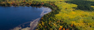
SEH wetland scientists were asked to delineate a 250-acre project area in a remote location in St. Louis County, Minnesota for an existing mining operation. With that much ground to cover, and in a short time, the team needed a way to make the best use of their, and the client’s, resources.
Solution
SEH scientists quickly and efficiently identified potential wetland areas for field review by using a combination of GIS and remote sensing techniques enabling them to perform a wetland analysis before the site visit. The remote sensing analysis used high-resolution, multi-spectral aerial imagery collected during both spring and summer. Lidar (Light Detecting and Ranging) data was also critical in the remote sensing efforts. Ground elevation was used to create several topographic models including slope, curvature and a wetness index used to model surface water patterns and locate areas of potential ponding. Point cloud lidar data helped characterize the wetland plant community type as well as boundary determination. With this combination of techniques, the field delineation process became more efficient, and the project was completed on time and under budget.
Project
Wetland Regulatory Planning and Permitting
Location
St. Louis County, Minn.
Client
Private
Services
- 3D Visualization
- Lidar and remote sensing analysis and modeling