

Wetlands are critical to our ecological, economic and social health. In this article and accompanying videos, Rebecca Beduhn walks through what wetland delineations accomplish for your projects, the equipment needed, what the process involves and much more.
For most people, the words swamp, marsh, bog and wetland mean a peaceful pond with cattails, water lilies and frogs. But contrarary to popular belief, wetlands are not always wet. Some wetlands are farmed, mowed for hay or maintained as lawns. According to the Clean Water Act and U.S. Army Corps of Engineers (USACE), all wetlands share these characteristics:
- Hydrology – The degree of flooding or soil saturation. The period of soil saturation varies according to several factors, including the climate conditions, soil texture and permeability, wetland type, the geographic location of the wetland and man-made disturbances.
- Soil – Wetland or “hydric” soils are soils formed in conditions of saturation (or wetter) long enough during the growing season to develop characteristics unique to wetlands. Depending on location, there are approximately 20 “hydric soil indicators” that can identify a soil as a wetland.
- Vegetation/plants – Wetlands are dominated by “hydrophytes” or water-loving plants. To determine if a plant community meets wetland criteria, data is collected to evaluate if a community is dominated by hydrophytes. The USACE has defined the “hydric indicator status” of more than 1,400 species of plants usually found in wetlands. Five categories describe these plants. After identifying and making a comprehensive list of the plants located in the community, a delineator will calculate the dominance of hydrophytes using several methods.
Benefits and purpose of a wetland
Wetlands provide many ecological, economic and social benefits. This is one critical reason why policies are in place when developments are planned in or around wetland areas. Specifically, wetlands provide habitat for fish, wildlife and plants; recharge groundwater and reduce flooding; provide clean drinking water; offer food and fiber; and support cultural and recreational activities.
Because of all the many essential needs they provide, wetlands are protected by federal, state and local regulations.
When do I need to a wetland delineation?
If you are planning a development project, building a new road or have an agricultural field that needs draining where a wetland may be disrupted or impacted, a delineation is your first step. Wetland delineations tell you precisely the wetland location within your project plan. To obtain a permit for impacting a wetland, the delineated wetland boundary must be approved by the USACE and, often, other local agencies that may have regulatory authority.
The best time to conduct a wetland delineation is during the “growing season,” the part of the year when soil temperature (measured 20 in. below the surface) is above biological zero (5°C or 41°F). A bud break on woody vegetation and visible “green up” denoting active vegetation growth is also a proxy for the start of the growing season. Plants dying or entering dormancy mark the end of the growing season. The growing season varies considerably both year to year and geographically.
How to conduct a wetland delineation
A wetland delineation should result in three findings:
- Delineation results map – This map should clearly define the boundaries of each delineated wetland or stream, the location of all data points and the area of investigation.
- Boundaries – Wetland and tributary boundaries should be clearly marked in the field with wetland flags to aid in agency verification.
- Report – The final report should include the delineation methods, results, data forms documenting the findings, photographs, climate conditions before and at the time of the delineation, and other relevant figures.
Understanding the findings you hope to achieve, here are the three steps of a proper and thorough wetland delineation:
Step 1 – Resource review
Whether small or large wetland delineation project, a delineator should prepare by researching the project area. This involves using mapping products such as aerial photographs and soil maps to identify potential aquatic resources. Some essential resources available:
- Aerial photos
- National Wetlands Inventory – U.S. Fish and Wildlife Service (USFWS)
- Soil survey by Natural Resource Conservation Service (NRCS)
- Topography
- Relative local or state-level maps that could exist for wetlands (e.g., state departments of natural resources often have localized maps of known wetlands and aquatic resources)
If you are working on a smaller project, merely having a map is all you need. But for larger projects when you're on a team, it's often best to determine in advance who will cover what areas.
I always try to import project limits in the Global Positioning System (GPS) unit so I always know where I am on the site in respect to the proposed project. I don’t want to delineate too much or too little.
– Rebecca Beduhn, SEH Natural Resource Scientist
Step 2 – Field gear and field procedures
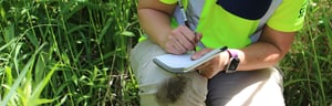
So, you’re ready to head out on a wetland delineation. Before you go, do you have the essential field gear? Here’s a check-list of the essential wetland delineation field gear recommended to perform your job at the highest level:
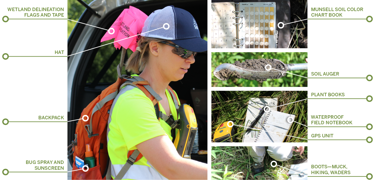
Additional field gear to pack and prepare for your wetland delineation:
- Cell phone
- Waterproof field camera
- Soil knife
- Two-way radios or “spot” phone for working in remote areas
- Rain jacket
- Food and water for long days
Now that you’re prepared with the recommended essential wetland delineation gear and a plan, you’re ready to venture to the project site and begin the wetland delineation. When you arrive at the project site, where should you begin? Is there an exact start and finish line?
“Generally, you can start anywhere,” says Rebecca. “I look at the vegetation around me, review the locations from my resource mapping and begin the delineation with a sample point.”
These are the field procedures to follow in both upland and wetland areas:
A. Look at the vegetation around you.
What types of vegetation do you see? It’s not uncommon to find vegetation in both upland and wetland areas. Rebecca will sometimes touch the vegetation to determine what the plant is. For example, Rebecca could feel edges on one plant picked during a delineation and, as a result, could identify the plant. “It helps to remember ‘sedges have edges,’” says Rebecca. “Many sedges are found in wetlands but not all of them. It’s important to identify the type of sedge to determine the hydric indicator status of that species.”
Other interesting vegetation found in this particular delineation is “sticky Willy.” Botanists won’t call it sticky Willy – they use the scientific names. Rebecca says some of the descriptive, common names can be helpful to remember a particular plant species. Other vegetation includes milkweed and reed canary grass – both of which can be found in uplands and wetlands. When you locate an area where the dominant vegetation is hydrophytic (i.e., grows in wetlands the majority of the time), you're on the right track to finding your wetland boundary.
In the video below, Rebecca walks through and discusses the importance of plant identification.
B. Locate the topographic break.
While not an accurate indicator, wetland boundaries are often associated with changes in topography, where the wetland is predominantly lower in the landscape.
C. Complete a soil sample:
- Using an auger, begin digging a hole or “pit” into the ground.
- With each dig the contents in the auger are placed on the ground around you (note: the soil is placed on the ground in the order in which it was extracted to recreate the entire soil profile from the top to the bottom of your pit).
- Dig a hole – typical soil depths are generally 18-24 in. below the ground to:
- Observe the soil to determine the presence or absence of hydric soil characteristics
- Observe hydrology including depth to the water table and saturated soils
- Identify disturbances
- Hue – dominant color of the soil [i.e., Red (R), Yellow-Red (YR), Green (G), Green-Yellow (GY) and so on]
- Value – light and darkness of the soil (i.e., the value indicates with a number like 2, 4, 6 and so on)
- Chroma – purity or strength of the soil color (i.e., the value indicates with a number, typically in the range of 2-14)
- According to the United States Department of Agriculture (USDA), three particle sizes make up soil texture: sand, silt or clay and all mineral soils are comprised by one or more of these soil textures. Organic soils may contain these soil particles but also dominated with dead organic matter derived from decaying vegetation and other biota found in soil.
- Determine soil texture by employing the “feel analysis” flow chart.
- Place a pink wetland delineation pin flag into the ground denoting the location of the soil profile and record the point into the GPS.
In the video below, Rebecca places pink wetland delineation flags identifying the wetland boundary. She also records GPS points as part of her delineation.
Additional conditions to note during a wetland delineation include the temperature (higher or lower than normal) and precipitation (wetter or drier than normal).
In the video below, Rebecca walks through how to conduct a soil sample during a wetland delineation.
Step 3 – The draft report
The content of your wetland delineation report should consist of:
- Introduction – Site description and purpose for the delineation
- Wetland delineation descriptions and methods – Definition, methodology, hydrophytic/wetland vegetation, hydric/wetland soils, hydrology
- Results – Description of the wetland identified and regulatory considerations
- Bibliography
- Tables, figures and appendices
After the draft report is prepared, the project owner then engages a wetland regulatory agency to review and confirm the results.
“We all vary in our approaches and analysis,” says Rebecca. “If the conditions change or something wasn’t identified accurately in the initial delineation, we fix it.”
In Minnesota, where Rebecca is located, an approved wetland delineation is valid for five years so long as conditions have not changed the boundary of that wetland during the five years since the initial approval. It's important to stay up with current regulations in your state to ensure you have full understanding of the validity period of an approved wetland delineation.
Wetland classification
Scientists classify dozens of wetland types, characterized by vegetation, soil type condition and degree of saturation or water cover. Agencies may require one or more of these types for all wetland delineations. In Minnesota, for example, wetlands are classified three ways:
- USFWS Service Circular 39 – Identifies wetlands, lakes and streams based primarily on hydrology. The publication defines eight wetland types in Minnesota.1
- Cowardin – Incorporates information on landscape position, plant communities and hydrology. This publication defines five main types of wetlands with numerous subcategories and modifiers. It is also the classification system used for wetlands described in the National Wetlands Inventory.2
- Eggers and Reed – A descriptive approach based on wetland plant communities occurring specifically in Minnesota and Wisconsin. This publication describes 15 types of wetlands.3
In summary
Wetlands are essential landscapes that provide ecological, economic and social benefits to the human and natural environment. As such, project owners must adhere to strict policies to ensure protection and proper development around these areas. Before you begin your next project, consider the steps and procedures above to keep your project moving forward.
About the Author

Rebecca Beduhn is a Natural Resources Specialist, Professional Wetland Scientist and Certified Minnesota Wetland Professional who specializes in hydric soils. She is committed to preserving our environment and spends her days conducting wetland assessments and delineations, preparing regulatory permitting documents and monitoring mitigation sites.
Cited:
- Shaw, S. P. and C. G. Fredine. 1956. Wetlands of the United States. U.S. Fish & Wildlife Service, Circular 39.
- Cowardin, L., M., V. Carter, F. C. Golet and T. T. LaRoe. 1979.
- Eggers, S. D., and D. M. Reed. 2014.